EXCAVATIONS AT COSA (1991-1997), PART 2: THE STRATIGRAPHY
Part 2: The Stratigraphy
> Trenches in the Area of the Forum, and IX D North
> Forum V
> Phase VII: Agricultural Activity
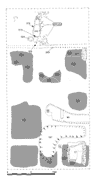
Phase VII: Agricultural ActivityAfter the house crumbled, some of the pis» collapse was disturbed by agricultural activity. This activity was manifested only by areas of broken pis», softer and with smaller mortar and plaster inclusions than the in situ collapse. The disturbance was most pronounced in the areas where the collapse was deeper; where the remains of the house were closest to the surface, in the area of the service suite, it was more difficult to distinguish between collapse and different periods of agricultural activity. With few exceptions, the disturbance left the pis» collapse around the walls of rooms intact. This pattern suggests that parts of the walls themselves were still visible and that cultivation was deliberately organized according to the original spatial divisions of the house. It also suggests that the agricultural activity took place on a relatively small scale and involved plants that required only shallow tilling and small plots: the produce grown here is more likely to have been on the order of onions than of wheat. The relative chronology of this cultivation is impossible to determine, since, almost universally, the only ceramic material recovered was residual pottery from earlier periods. The only exceptions are a few sherds of African Red Slip D, found in the collapse of the aedicula (240), and several sherds found in a thick upper layer of sediment (223) that completely filled the central depression created by the collapse of the walls of the garden. Both groups of sherds point to 4th or 5th c. activity and provide the only ceramic evidence we have for the frequentation of the area after the beginning of the 3rd c. A.D. In the absence of more specific evidence, it is difficult to determine whether the plots were all used at the same time or cultivated one after another at any point from the 4th c. A.D. to the 10th.The organization of the cultivated patches also affected our stratigraphic recording: since the soil disturbed by cultivation was, in most cases, non-contiguous, the traces of agricultural activity were assigned different unit numbers in each area of the house. In the front of the house these were 98, 99, 134, 136, 142=246, 145, 160, and 208. In addition, 137, in room J, covered 134 and 136. Toward the south corner of the trench, the remains of the house were much closer to the surface, and consequently the various phases of agricultural disturbance were less clear than they were to the east. Nevertheless, it was possible to individuate several strata that seemed to have been produced by the same sort of cultivation: 130 in M, 164 in P, 284 in both M and P.
[ 1 2 3 next ] |
Part 2: The Stratigraphy
> Trenches in the Area of the Forum, and IX D North
> Forum V
> Phase VII: Agricultural Activity
© 2002 Adam Rabinowitz and Elizabeth Fentress
Design © 2002 Adam Rabinowitz and Nicholas Rabinowitz
All rights reserved.