EXCAVATIONS AT COSA (1991-1997), PART 2: THE STRATIGRAPHY
Part 2: The Stratigraphy
> The Arx and the area to the west (IV G)
> IV G
IV G(fig. 48 and pl. 33)(Michelle Hobart, 1992)
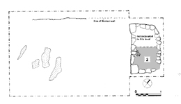
ObjectivesThe investigation of a crude structure of dry stone and the area around it.DimensionsAn area 6 x 10m. was cleared, next to a wider area measuring 14 x 25 m.StratigraphyThe area excavated lies within the insula delimited by streets O and 4: on its northwest side the trench was bordered by a Roman terrace wall, 8, presumably separating two houses. This formed a right angle with 7, which again may have been a party wall. No stratigraphy was found associated with this house, and it seems that the whole area was cut away almost to bedrock, in order to provide a level area for cultivation. We thus are unable to discover whether this area lay within the Augustan settlement. Against wall 7 was built a subrectangular structure, 5, 2.5 x 3.2m., which may be interpreted as a hut or a pen. The walls survive to one course, and are formed of large, crude blocks, similar to those found within the structure in the destruction layer, 2. One of the corners is not square, and the whole structure is rather haphazard. The floor, 6, was of compacted beaten earth, with a little pot and bone. No dating evidence was recovered, except for a lead slingshot bullet similar to those found on the Arx. Both its size and the rough stone foundations are similar to the huts in Forum V and Arx VI, and a medieval date cannot be excluded. |
Part 2: The Stratigraphy
> The Arx and the area to the west (IV G)
> IV G
© 2002 Adam Rabinowitz and Elizabeth Fentress
Design © 2002 Adam Rabinowitz and Nicholas Rabinowitz
All rights reserved.