EXCAVATIONS AT COSA (1991-1997), PART 2: THE STRATIGRAPHY
Part 2: The Stratigraphy
> The Sample Trenches
> L4
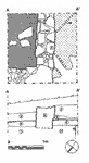
L4(fig. 80)(Titus Bicknell, 1992)
The earliest context is a straight cut in bedrock, 10, running at 45 degrees to the Roman grid, directly north-south. It appears to be edged with at least one faced block, and may represent the wall of some construction. Forming a corner with it towards its northern end was another cut, not clearly visible beneath the Roman wall. Over these lay a clean red layer, 7/11, containing four sherds of impasto pottery. Over this surface were built the Roman walls, 4 and 5, of faced, regularly coursed limestone blocks, standing 60cm. high. Outside this wall 9 may represent the makeup for street: although very similar to 7/11, it contains a sherd of black glaze pottery and appears to butt the Roman wall, so it is probably redeposited. It is surfaced with yellowy gravel, 8, 4cm. thick and very compact. There is no sign of paving blocks. Within the building 6, of red earth with pottery and charcoal, probably represents a floor or garden level. Over it a midden or occupation layer, 5, contains a certain amount of bones and household refuse. This is covered by 2, containing much clay and probably deriving from collapsed pis» de terre. Outside the building a midden, 3, accumulated over the road surface, and the whole was covered by topsoil. No Arretine pottery was found in the trench, which suggests that this insula was not reoccupied. |
Part 2: The Stratigraphy
> The Sample Trenches
> L4
© 2002 Adam Rabinowitz and Elizabeth Fentress
Design © 2002 Adam Rabinowitz and Nicholas Rabinowitz
All rights reserved.