EXCAVATIONS AT COSA (1991-1997), PART 2: THE STRATIGRAPHY
Part 2: The Stratigraphy
> The Sample Trenches
> R7
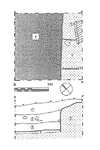
R7(fig. 93)(Hettie Veneziano, 1992)
The east wall of the building is indicated by an 80cm. deep, straight cut in bedrock along the southeast edge of the trench. There may have been a door in this wall, for half of it lies 40cm. below the other half, and traces of a posthole were found at the junction. The floor was also composed of cut bedrock, with a thin layer of beaten earth, 4, above it; it lay 30cm. under the supposed doorsill. Above this a much thicker layer of decayed pis», 3, seems to mark the destruction of the building. It was covered by tumbled rocks in a dark brown soil, 2, not very different from the topsoil. No ceramic material later than the Republican period was found in the trench. |
Part 2: The Stratigraphy
> The Sample Trenches
> R7
© 2002 Adam Rabinowitz and Elizabeth Fentress
Design © 2002 Adam Rabinowitz and Nicholas Rabinowitz
All rights reserved.