EXCAVATIONS AT COSA (1991-1997), PART 2: THE STRATIGRAPHY
Part 2: The Stratigraphy
> The Eastern Height, EH I-VIII and X C
> X C
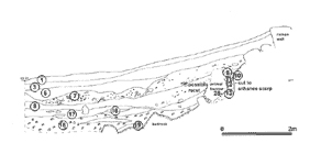
X C(fig. 58)(Tom Dawson and Michelle Hobart, 1995)
ObjectivesThe trench was excavated to the southeast of the northeast gate. The aim was to understand the relationship between the pronounced scarp, a visible medieval wall, and the rest of the early-medieval defensive system. The northwest-southeast arm was hand-excavated to the depth of one meter, and thereafter excavated by machine, with the sections cleaned, studied and drawn. The northeast-southwest arm was then begun, but in the event only hillwash was removed, and the results were inconclusive.DimensionsThe trench was L-shaped, running northwest-southeast, then turning at a right angle towards the southwest. The first arm measured 14 x 3m., the second 7 x 2m.StratigraphyOver a layer of the red, silty natural soil found over bedrock everywhere on the hill of Cosa (13), the earliest stratigraphy in the trench consisted of series of entirely clean layers leveling up the slope of the bedrock. The predominant matrix was of a green clay, similar to that found in the swampland below the hill around the lagoon and the Lago di Burano (10, 12, 18). In this matrix were lenses of other material, also deriving from local geological formations: a pure white calcareous silt (9, 11, 17, 19), and patches of the red silt of the natural loŒss (16). The way these layers lay strongly suggested that they were redeposited, and although no dating material was found in them, they appear to fill the hollow in the bedrock between the sinkhole and the city walls. This would suggest that their deposition was contemporary with the construction of the city walls, whose outer face at this point is in fact much lower than its inner face.Two Roman walls were visible. The construction trench for wall 26 was apparently cut into this series of fills (some doubt remains as we were unable to excavate so close to the wall), with a probable return up-slope, 25. The truncation of the stratigraphy and incompleteness of the excavation upslope from wall 26 leaves us with some uncertainty as to the date of these walls, but their construction technique, of dry stone, roughly faced blocks, and their alignment with the Roman town plan, strongly imply that they are in fact Republican, perhaps dating to the early second century. An alternative hypothesis, that they constitute a gate bastion contemporary with the defensive scarp, was rejected for want of better evidence. Wall 26 itself is sharply canted outward, due probably to colluvial pressure from above. Although the two walls form a clear corner, and therefore might indicate an angle in the street grid, the fact that the stratigraphy to the northwest of them has been cut away does not allow us to come to any conclusions. No contemporary stratigraphy was associated with these walls to the northwest. There, a cut slopes steeply away from and parallel to 26 (pl. 43). The cut seems to have enhanced the existing slope, creating a scarp that climbs 2.40m. in 2.80 meters, with a gradient of almost 1:1. From the top of the Roman wall the slope is more gentle, continuing uphill with a gradient of 1.7:5. Although an animal burrow (27, fill 14) has confused the section, it is clear that the stratigraphy associated with the Roman wall is missing at this point, while the truncation of layers 9-12 leaves no doubt that they were cut away previous to the creation of the burrow. In conjunction with the scarp created by the cut the Roman city wall was cut away, leaving a gap ca. 10m wide in the Roman defenses (see pl. 27). This can only be explained by a desire to avoid an overhead passage past the scarp, which would have enabled attackers to mount the wall in the vicinity of the northeast gate and engage the defenders from above. A similar cut in the Roman walls is visible at the other end of the circuit, below the catapult base. To the southwest of the trench the scarp stops abruptly, in conjunction with what appears to have been a road leading up from the northeast gate towards the castle. This is marked by a long wall, 24, running in a straight line over 19 meters in the direction of the castle at an angle of around 10 degrees to the Roman alignment. It is built of large blocks, dry-laid, which seem to derive from the polygonal masonry of the Roman city wall. Although roughly faced on its southwest side, it does not seem to be an adequate foundation for a wall of any height. All late medieval walls at Cosa were mortared, with the exception of the berm wall (EH VI, NE ext, 203) and the catapult base (EH). The wall terminates at the edge of the scarp, and may have been constructed at the same time, possibly with the blocks removed from the city wall to create the gap. Its function is in no way clear: no constructions were observed inside it, and it may simply have supported a low cultivation terrace, forming a boundary between it and the road. Dating for these features, the scarp, the gap in the wall, and the road, is uncertain. It is, however, likely that they are contemporary with the double ditch and bank in Forum II. The scarp is directly aligned with the lower ditch, and seems to form part of a single circuit, with a main gate just southwest of the trench and a postern at Forum II. It should be noted that the path leading across the ditches in Forum II was also marked by a wall on one side. The base of the cut was filled by a clean, silty layer, 15, covered by a thicker layer of clean hillwash, 8. Over this a thick layer, 7, contained much construction material (largely Roman), and seems to suggest a period of cutting or destruction up-slope. We may perhaps relate this layer to the construction of the castle, when much robbing of the Roman structures on the hill took place: a similar layer was found as the top fill of the early ditch in EH II. Over layer 7 clean layers of colluvial material (6, 3, 21-23) bring the slope up to a 'natural' gradient of 1:6, and are probably post-medieval in date. |
Part 2: The Stratigraphy
> The Eastern Height, EH I-VIII and X C
> X C
© 2002 Adam Rabinowitz and Elizabeth Fentress
Design © 2002 Adam Rabinowitz and Nicholas Rabinowitz
All rights reserved.