EXCAVATIONS AT COSA (1991-1997), PART 2: THE STRATIGRAPHY
Part 2: The Stratigraphy
> The Eastern Height, EH I-VIII and X C
> EH I
EH I(fig. 51 and fig. 52)(Gretchen Meyers and Ben Lyons, 1993)
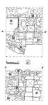
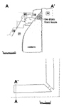
ObjectivesEH I is one of four trenches excavated in 1993 to establish the limits of the tower on the Eastern Height. It lies on the western side of the mound.DimensionsThe trench, initially measuring 2 x 5m., was expanded after the discovery of the cistern to 10 x 3m.StratigraphyThe excavation was not carried below the destruction layers, so that the earliest stratigraphic unit is the western wall of the tower, 36. This was preserved to a height of 106.58m. over sea level, and built from a maximum height of 103.25m. (the lowest point visible within the cistern). In a second phase, two structures were built against it. The first of these was a cistern, 37, measuring 2 x 7m., 3.6m. high. This was constructed with a battered wall of rubble masonry that sloped up against wall 36 (pl. 35). Built against this, but probably contemporary with it, was an inlet basin, 40, supported on a rubble construction, 38, and connected to the cistern by a terracotta pipe, which was found blocked with a plug of pumice stone (pl. 36 and pl. 37). In a subsequent phase this inlet basin was buttressed with a roughly triangular wall in rubble masonry with gray mortar and stones, 39.At the time of the destruction of the tower the bottom inlet basin was filled with a yellowish sandy silt with small pebbles and no pottery, 34, presumably a deposit settled out of the water within it. A layer of soft orange sand, 35, covered the step in front of the manhole leading into the cistern, and seemed to slope up against the buttress below it. Above this layer, a spread of ash, 33, indicated a fire nearby. All of these layers lay under the destruction levels of the main building. Layer 32 consisted of massive quantities of stone and mortar, 2-3m. deep. It was not fully excavated. Above it, a layer of similar stones mixed with a large quantity of leaf mould, 31 suggests the erosion of the same layer from further up the hill. |
Part 2: The Stratigraphy
> The Eastern Height, EH I-VIII and X C
> EH I
© 2002 Adam Rabinowitz and Elizabeth Fentress
Design © 2002 Adam Rabinowitz and Nicholas Rabinowitz
All rights reserved.