EXCAVATIONS AT COSA (1991-1997), PART 2: THE STRATIGRAPHY
Part 2: The Stratigraphy
> The Eastern Height, EH I-VIII and X C
> EH II
EH II(fig. 53)(Miranda Richardson, 1993)
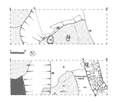
ObjectivesExcavated to the west of EH I, EH II was a long cut to investigate the outer circuit of walls visible down slope from the tower.DimensionsThe trench measured 10 x 3m. The initial cut was made with a mechanical digger, which removed most of the destruction deposit and tumble from the wall. Thereafter excavation took place by hand.StratigraphyThe earliest stratigraphic unit is a ditch, 26, cut into bedrock and running roughly east-west. U-shaped in profile, the cut is much steeper on the up-hill side (up to 1.5m. deep), and on average 2.8m. wide. It seems to be turning a corner inside the narrow confines of the trench, in order to encircle the summit of the hill. It can be traced outside the trench to the southwest by following visibly cut bedrock, and appears to include the flat surface of the hill outside the castle. Along its inner edge, two clear cuts in bedrock, 32 (fill 33) and 30 (fill 14), may represent postholes for a palisade. Another cut, 31, is less certain. The earliest fill of the ditch was a hard, compact red silt, 28, deriving from the paleosoil of the hill. This was possibly re-cut (the suggestion is due to the steep angle between it and the next fill), and the subsequent fill, 27, was far stonier. The rare material in these layers was entirely medieval, suggesting that they accumulated in situ rather than being re-deposited from elsewhere. 24, the next fill, may have been deliberate, as almost a third of the material was residual Roman. This was thicker, with few stones, and a minimum of bones. Its surface was compacted (23), and it may represent the first phase of leveling for the castle. Indeed, it is in this period that we believe that the Roman buildings on the top of the hill were leveled and robbed for the building of the castle (EH VI). 22, a thick layer of earth and stones lying above it, is almost certainly a context produced by building activity, possibly the preparation of the hilltop for the tower. Within it, a large squared block, 25, is reminiscent of those used to build the circuit wall. The relationship with 19, which also underlay the wall, is not clear: from one section it appears that 19 is actually cut by the ditch 26, but this may be illusory, and there is no certainly early material in 19. It is thus probable that 19 forms part of the same sequence of fills and tips as 22.
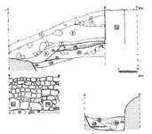
The outer wall of the castle, 15, was built without a foundation trench on the outside, from a point 100.36m. over sea level (pl. 38 and fig. 54). It was 1m. wide, constructed of large square blocks in a white-gray mortar, forming a straight edge on its northern end, which suggests the presence of a gate in this phase. The position of this gate coincides with that of the earlier road leading up to the summit from the 'Porta Romana' through the ditched defenses (X C). 13, a compaction on top of 22, may represent contemporary ground surface during this phase, or the surface of the road. 12, an ashy gray layer lying over 13, may be interpreted as occupation refuse. In a second phase the gate was blocked by a new construction, 16, and wall 15 was partially rebuilt. The construction technique of 16 was less careful: irregularly coursed and roughly faced stones in yellow mortar. Traces of this mortar were found in the layer associated with this reconstruction, 4/11, with a compacted surface. The new wall seems to have been defended by a shallow ditch, 20, which cuts layer 4 close to the line of the earlier ditch. The ditch was no more than .8 m. deep at this point, and represents more an enhancement of the slope than a real ditch. However, there was probably a new gate to the south, and the ditch may have been terminating at this point. It also closely resembles the shallow ditch excavated in the extension to EH VI. This ditch was filled with a fairly homogenous layer of earth, with little pottery, although it included several sherds of maiolica arcaica and was thus certainly later than the end of the twelfth century. Sealing it was a compacted layer of earth, 7, which provided a flat surface outside the wall, possibly a deliberate berm. This was the last occupation layer associated with the defenses: over it a series of destruction layers (5, 6, 2) contain large amounts of stones that certainly tumbled from the wall. They are all covered by topsoil, 1, in which the presence of large stones shows that the wall continued to disintegrate into the modern period. |
Part 2: The Stratigraphy
> The Eastern Height, EH I-VIII and X C
> EH II
© 2002 Adam Rabinowitz and Elizabeth Fentress
Design © 2002 Adam Rabinowitz and Nicholas Rabinowitz
All rights reserved.