EXCAVATIONS AT COSA (1991-1997), PART 2: THE STRATIGRAPHY
Part 2: The Stratigraphy
> The Eastern Height, EH I-VIII and X C
> EH IV
EH IV(fig. 56)(Ben Lyons, 1993)
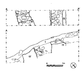
ObjectivesEH IV, on the east side of the Eastern Height, was one of four trenches intended to delimit the tower.DimensionsThe trench measured 1 x 5m., and was excavated down to the crests of the walls.StratigraphyTwo walls were present in the trench, but the confined space made it impossible to excavate low enough to establish the relationship between them. The westernmost, 14, was well faced with limestone blocks in a white mortar, 0.8m. wide. This is less substantial than the walls of the tower, and may represent a subsidiary building, although the mortar is very similar. The wall was apparently destroyed down to 105.64m. above sea level, for 13, of stones in a yellow mortar, seems to represent a rebuilding - unless, of course, 14 was never more than a courtyard wall. Outside it, 1 meter away, another wall, 15, runs at a slight angle to it. This was far more roughly built of limestone in a gray mortar, 0.7 m. wide, with only the western face surviving. It may be interpreted as part of a house or barn within the cassero walls. |
Part 2: The Stratigraphy
> The Eastern Height, EH I-VIII and X C
> EH IV
© 2002 Adam Rabinowitz and Elizabeth Fentress
Design © 2002 Adam Rabinowitz and Nicholas Rabinowitz
All rights reserved.