EXCAVATIONS AT COSA (1991-1997), PART 2: THE STRATIGRAPHY
Part 2: The Stratigraphy
> The Eastern Height, EH I-VIII and X C
> EH V
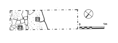
EH V(fig. 57)(Miranda Richardson, 1993)
ObjectivesThis small trench was designed to delimit the southern edge of the tower.DimensionsThe trench measured 0.8 x 2.8m.StratigraphyBecause of the massive amount of tumble and tree roots, excavation was only carried out down to the crest of the wall. This was found under 1m. of tumble, and only its outer face was present within the limits of the excavation. In all ways similar to the tower walls in EH I and III, it consisted of a face of limestone blocks with and infill of small stones and some tile in a white-gray mortar. The walls were preserved to a height of 105.97m. above sea level. This confirms the evidence from inside the cistern, that its vault was not preserved at the southeast corner of the tower, as the top of the vault on the western edge stood at 106.58m. above sea level. |
Part 2: The Stratigraphy
> The Eastern Height, EH I-VIII and X C
> EH V
© 2002 Adam Rabinowitz and Elizabeth Fentress
Design © 2002 Adam Rabinowitz and Nicholas Rabinowitz
All rights reserved.