EXCAVATIONS AT COSA (1991-1997), PART 2: THE STRATIGRAPHY
Part 2: The Stratigraphy
> The Eastern Height, EH I-VIII and X C
> EH VI
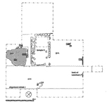
EH VI(fig. 12 and fig. 37)(Nicholas Churchill, 1993; Elizabeth Fentress, 1994; Joanna Hambly and Elisabetta Gliozzi, 1995)
ObjectivesThe trench was designed to investigate what appeared to be a leveled area of bedrock lying south of the summit of the hill and north of the 'tr»buchet base'. This area appeared to have been deliberately leveled, possibly at the same time as the creation of the ditched defenses. The discovery of a sunken-floored building led us to reopen the trench in May of 1994, for a brief campaign to finish the excavation of the lower levels of the hut. In July 1995 the trench was greatly enlarged, to include as much as possible of the leveled platform in the hopes of better understanding the early medieval features on the hill. The discovery of a republican temple in the center of the platform led to a further enlargement to the northwest, in order to understand the context of the temple. A final extension (known as the northeast extension, and written up separately below) linked EH VI to the outer wall of the castle. Bedrock was reached in most of the upper trench and in the northeast extension, but time did not permit the complete excavation of a second sunken-floored building northwest of the temple.DimensionsThe trench was irregular in shape, initially a rectangle of 10 x 11m. with a corner missing. It was extended in 1995 to 27.5 x 20m., with an extension to the east of 11 x 13m.StratigraphyCutting and erosion had destroyed much of the stratigraphy on the top of the hill. The earliest activity appears to have been the laying out of street R, which runs from southwest to northeast and probably continued across the center of the site. Our evidence for it is slight, however. The fa¡ade of the temple is exactly aligned with its northwest edge. A second road, 15, seems to have run along the northeast edge of the trench. It has a clear corner with R, is marked on both sides by small stubs of walls, to the northeast by 184, at the edge of the trench, and to the southwest by 185. There are no traces of paving stones on this road. To the north, it has a smooth beaten earth surface with some slight cobbling, 5, while in many places even this surface is missing, and the flattened bedrock reveals the straight cuts of the metal tools used to level it. On street R, however, medieval robbing seems to follow the line of the road and might be related to the removal of paving stones during the construction of the twelfth century castle. However, it seems more likely that these roads were used only for a brief period prior to the construction of the temple and its sanctuary.For the sanctuary itself our evidence is sadly scarce. The whole top of the hill appears to have been leveled off to create an open space measuring perhaps 29.5m. (100 Roman feet) by something over 31m. The temple was sited in the middle of this space, its center point exactly 14.78 meters (or 50 roman feet) from the inner face of wall 184, which may have been transformed into the northeast sanctuary wall at this point. A construction trench for the temple walls was cut into bedrock (232, filled by 231). To the northwest, where the ground began to slope away steeply, the bedrock was simply leveled to provide a solid foundation. In one case, toward the northern corner of the temple, the bedrock was shaped into a foundation block taking the same form as the polygonal masonry. On the southwest fa¡ade of the temple the construction trench cut into the line of the road, and the construction fills (227, 228, 230) spread out onto the road itself. These contained frequent spalls and occasional tiny fragments of pottery and tile. The eastern corner of the temple is marked by a circular posthole, 60cm. wide (250). If it is not in fact medieval, this might be related to the scaffolding that served to help lift the large blocks of the podium in place. From the two preserved courses on the northwest side, 234, the masonry technique used in the construction of the temple appears directly comparable to that of temple D on the Arx. The podium was filled with yellow earth containing plentiful fragments of tile and wall plaster (112, 244), which suggests that the fill derived from earlier buildings in the immediate area of the temple. These might be represented by the stub wall along the line of the cardo, 185. As nothing else remains of this building, we may presume it was completely removed during the clearance of the sanctuary area. The podium fills continued down to bedrock, 60cm. below the preserved surface, which again suggests that the clearance of any earlier structures on top of the hill was very thorough. The robbing of the structure prevents us from knowing anything about the plan of the temple except its dimensions, for the line of the cella wall was certainly marked out onto the surface of the podium, rather than within its foundations. [ 1 2 3 next ] |
Part 2: The Stratigraphy
> The Eastern Height, EH I-VIII and X C
> EH VI
© 2002 Adam Rabinowitz and Elizabeth Fentress
Design © 2002 Adam Rabinowitz and Nicholas Rabinowitz
All rights reserved.