EXCAVATIONS AT COSA (1991-1997), PART 2: THE STRATIGRAPHY
Part 2: The Stratigraphy
> Trenches in the Area of the Forum, and IX D North
> IX D North
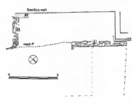
IX D North(Teresa Clay, 1991, and Joanna Hambly, 1992)ObjectivesThe cleaning of the Basilica in 1991 and the discovery that the structures on it were all Byzantine led us to ask the extent of this occupation, which clearly depended on the substantial road running up from the northeast gate, the 'Porta Romana'. Further, 1951 excavations in the trench 'isolating' the Basilica (ENE 5, 6, 7) had revealed apparently late walls in this area. The trench was thus started in 1991, and its excavation continued in 1992.DimensionsThe trench measured roughly 10 x 13m., but was rather irregular in shape: an olive tree occupied the center, and another two the northeast edge. Further, the central part of the trench was only excavated down to the collapse of the Basilica wall: at the suggestion of Dr. Ciampoltrini of the Soprintendenza this was conserved. In no area was bedrock reached, although the cleaning of the 'isolation trench' and the features associated with it gave us a clear idea of the stratigraphy.Stratigraphy
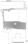
The earlier houses were destroyed during the construction of the Basilica, leaving the pis» de terre deriving from wall 2 in a large heap (25). The construction trench for the Tribune of the Basilica was 50cm. wider than the wall, and was filled with stone footings, whose mortar laps onto wall 2 (36, 37). A similar consÇtrucÇtion trench for the Basilica cut wall 35 (41). During the later Republican period and the Augustan occupation the area remained open, becoming a dumping ground during the first quarter of the 2nd c. A.D., when a rich midden deposit, 17, accumulated. This consisted of gray silt containing discrete lenses of other material (sand, clay) and huge quantities of amphorae, fine wares, glass, bronze and iron objects. The deposit appears to be a general rubbish tip of household and destruction debris. It is not, however, associated with anything structural in the trench.
These features should probably be associated with RichardÇson's 'Level III': (8/6/1951) ÏExcavation of tribune vault reveals firm rammed earth floor over a fill of debris through and just within doorway. This level (II) followed outside and found to continue as rammed earth floor...Ó (26/6/1951) ÏDirectly beneath level II appeared the floor of Level III, in part (SE) of rammed earth in part (NE of irregular rough cement of broken stone and friable mortar). To this floor corresponded a rough rubblework sill across the archway of the tribune vault. At this level a drainpipe traversing the NE wall of the enclosure (3) discharged into a diagonal channel that ended in a box-like depression before tribune vault arch. In angle of tribune and Basilica square stone manger set in cement floor. This arrangeÇment evidently involved use of trib. vault as stable.Ó RichardÇson is evidently correct in interpreting the whole ensemble as an area for the enclosure of animals, and other apparently agricultural activities.
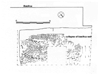
With the exception of a small metal ornament, no contemÇporary finds were associated with any of these features. It is thus impossible to be certain of their date, and we must proceed by association: the cemetery with the 6th c. church lying just above it, and the road with the 6th c. ramp running up through the Curia. The collapse of the wall of the Basilica/Odeon, which must have been used by the church, occurred at sometime after the abandonment of the cemetery. It fell outward from the platform, and its collapse is relatively coherent in the area of the trench, where the string courses of bricks can be easily traced (5b: pl. 65 and fig. 77). Lapping over the collapse of the wall was a very compacted yellowy-brown surface, 8, containing large quantities of stone, mortar and tile, suggesting a heavily trampled exterior surface such as a yard or sheep-pen. 12th and 13th c. pottery was found in these layers, but there is some possibility of contamination from the layers above. Modern layers included 9, composed of a series of dumps of tile, stone and mortar and much mixed debris, increasing gradually in depth downslope towards the northeast. Traces of a track, path or barrow-run (7) and a compact mortar spread just under topsoil (6,10) are probably connected with the 1951 excavations, as were the successive tips of earth. |
Part 2: The Stratigraphy
> Trenches in the Area of the Forum, and IX D North
> IX D North
© 2002 Adam Rabinowitz and Elizabeth Fentress
Design © 2002 Adam Rabinowitz and Nicholas Rabinowitz
All rights reserved.