EXCAVATIONS AT COSA (1991-1997), PART 2: THE STRATIGRAPHY
Part 2: The Stratigraphy
> The Sample Trenches
> N4
N4(fig. 83)(Justin Runestad 1992)
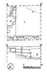
A shallow cut, 9, filled with what may be a lens of sandy subsoil, 10, appears to cut the natural subsoil of the hill 11. Over these, 7 may be a further layer of subsoil or, more likely, a makeup derived from the subsoil for the construction of the building. Over this were built the dry-stone walls of the insula, 4 and 5, with a clean layer of earth, 3, representing a yard or garden surface. Several sherds of archaic impasto in this layer, including one with a finger-impressed cordon, suggest the presence of an archaic cemetery or settlement in this area. Over it, and the walls, lies a relatively clean layer of decomposed pis» de terre, 2, with wall plaster fragments as well as a little household rubbish. Two sherds of Arretine pottery in this destruction deposit suggest that this area was not included in the Augustan settlement. It was cut by a stone filled pit, (8, fill 6), which remains difficult to interpret. Both were covered by topsoil, 1. |
Part 2: The Stratigraphy
> The Sample Trenches
> N4
© 2002 Adam Rabinowitz and Elizabeth Fentress
Design © 2002 Adam Rabinowitz and Nicholas Rabinowitz
All rights reserved.