EXCAVATIONS AT COSA (1991-1997), PART 2: THE STRATIGRAPHY
Part 2: The Stratigraphy
> The Sample Trenches
> N5
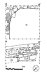
N5(fig. 84)(Nicholas Churchill, 1991)
The depth of deposit prevented the excavation of this trench below 1m. The stratigraphy consisted entirely of destruction deposits, lying against the two walls at the corner of the insula, 8 and 9 with, between them, a curious square stone foundation, 11. In 8, a stretch of tiles may indicated some kind of sill, rather than a leveling course, but we have no way of knowing how far it lay above the floor. The lowest destruction deposit (7) consisted of a thick layer of decomposed pis» de terre, dated by a sherd of late italic pottery to the period after A.D. 50. It is, however, likely that the building was not abandoned until late in the 1st c. A.D., for the sequence of tips covering the walls (2, 3, 4, 5, 6) , composed of alternating construction debris and rich midden deposits, were all dated to the period A.D. 80 - 130 by ARS form Hayes 8A : in the uppermost tip a coin of Hadrian confirms this date (catalogue n. 67). Sherds of window glass in the construction material may derive from the city baths on the other side of the street. |
Part 2: The Stratigraphy
> The Sample Trenches
> N5
© 2002 Adam Rabinowitz and Elizabeth Fentress
Design © 2002 Adam Rabinowitz and Nicholas Rabinowitz
All rights reserved.