EXCAVATIONS AT COSA (1991-1997), PART 2: THE STRATIGRAPHY
Part 2: The Stratigraphy
> The Sample Trenches
> O4
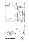
O4(fig. 86)(Ruth Van Dyke 1991)
On the southeast side of the trench a wall, 4, was preserved one course high, with a large square block visible in the east corner. A second possible wall, 5, was visible in the north corner, with what appears to have been a door between the two. Their foundations were cut directly into bedrock, which was apparently leveled with a layer of earth, 3, to form a rough surface prior to the building. This, and the foundations of wall 4, were directly covered by 2, which was a reddish soil with mortar and tile fragments, poorly compacted. This may have been a makeup for a floor, but was not itself a surface, and no surface was present. A sherd of Arretine pottery suggests a date between 35 B.C. and A.D. 50 for the formation of the layer, although the building itself is almost certainly Republican: it may be that earlier layers had eroded away after the building was abandoned, and that 2 represents a small accumulation of material in this part of the site during the period of the Augustan settlement. Southeast of wall 4 a large street cobble overlies 3, covered by 5, a layer very similar and possibly equal to 2. Over both lay 1, possibly a colluvial deposit from the Arx, which contained a sherd of 6th c. pottery. This was covered by topsoil. |
Part 2: The Stratigraphy
> The Sample Trenches
> O4
© 2002 Adam Rabinowitz and Elizabeth Fentress
Design © 2002 Adam Rabinowitz and Nicholas Rabinowitz
All rights reserved.