EXCAVATIONS AT COSA (1991-1997), PART 2: THE STRATIGRAPHY
Part 2: The Stratigraphy
> The Sample Trenches
> O4.5
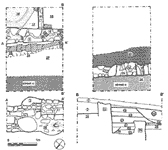
O4.5(fig. 87)(James Duff, 1992)
Excavation was not completed to Republican construction levels, because of the depth of deposit. The Republican wall of the insula was found partially destroyed, and covered with a series of tips of destruction material (35, 34, 33, 32, 31). The lowest of these, 35, was cut by a trench along wall 26, probably to rob out the facing stones (36, fill 37). These brought the ground level almost up to that of the destroyed wall. From this level a new building was constructed, with a side wall, 3, of mortared stones, 1.20 meters southeast of that of the Republican building: this obviously suggests a widening of the road. A door led from this road to the street, under whose threshold ran a drain, composed of a length of terracotta piping protected with broken amphorae and thick mortar (28, 25, cut 29). Over this drain, the ground outside of the building was leveled up by tips of material (27, 30), and surfaced with a thick layer of hard-packed red earth and stones, 23. Inside the building a party wall of pis» de terre, 11, ran at right angles to 3, just inside the door. Both faces of this thin wall were plastered, and its southwest face may have been reinforced by tiles, as a single vertical tile 12, suggests. The floor of the entrance corridor was apparently of beaten earth, 18. To the northeast of this was a floor of hydraulic plaster, with quarter-round mouldings made up with earth 16, 17. The drain may have led from this room, but we cannot be sure. The whole building is almost certainly part of the Augustan settlement, although 27 contained two sherds of late Italic pottery, which may represent contamination from a cut at a higher level. In a subsequent phase the street door was blocked with mortared stones and tiles, 4. At the same time street O was apparently resurfaced, with dark earth and stones (22). This can be dated to the end of the 1st c. A.D. by sherds of ARS form Hayes 8A. A subsequent surface or accumulation, 19, contained a large amount of occupation debris, and was cut by a shallow channel running parallel to the wall. This lies 0.9 meters from the wall, and may represent a crude gutter to carry water from the eaves. The fill of this gutter, 20 and 24, was fairly clean, and was covered by a final surface, 8. Both 8 and 19 contained no material later than A.D. 130. This was also true of the destruction layers, (18, 15, 14, 13, 5, 2) which contained large amounts of white wall plaster. |
Part 2: The Stratigraphy
> The Sample Trenches
> O4.5
© 2002 Adam Rabinowitz and Elizabeth Fentress
Design © 2002 Adam Rabinowitz and Nicholas Rabinowitz
All rights reserved.