EXCAVATIONS AT COSA (1991-1997), PART 2: THE STRATIGRAPHY
Part 2: The Stratigraphy
> The Sample Trenches
> P5
P5(fig. 89)(Nicholas Churchill, 1991)
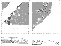
The walls of the building were of mortared stone (wall 26) with large fragments of roof tile (wall 25). They appear to have been contemporary: 25 being an external wall of the building, and 26 an internal wall, with a space for a door between it and 26. The northeast end of 25 was apparently destroyed by later disturbance. In the southwestern portion or the trench a thick layer of clay, 22 appears to have been an original floor: it was covered by a thick deposit of mortar, 15 which is possibly to be interpreted as destruction debris. The presence of Arretine pottery thorough out this sequence suggests that the building was rebuilt during the Augustan period: we have no trace of the earlier, Republican building. Although the subsequent layers appear to have been heavily disturbed, no pottery later than the African cooking wares Hayes forms 23 and 197 was found in the trench, which suggests that it was abandoned in the second half of the 1st c. A.D. The rest of the sequence was misinterpreted during excavÇation, and the following interpretation is being written three years later, on the basis of plans and photographs, and is based as much on our subsequent knowledge of the site as on this evidence. Under topsoil a shallow cut, 5, was identified, just over a meter wide, appearing to turn east at its southern end, 10. The cut was lined by postholes (3, 4, 6, 7, 9), to which one could add 19, packed with cobbles and lying in the same alignment, but only identified further down. Inside this limit lay a compacted surface 8. A second compacted surface, 23, lay under 8, and some of the postholes were only recognized at this layer, including two possible internal posts, 20 and 21, not aligned with the first group. The fact that the alignment of these two surfaces, the cut, and the postholes remains constant, at a diagonal across the trench, as well as the consistent disturbance of the Roman remains along the same alignment, suggests that they all form part of the same feature. Interpreted during excavation as a field boundary, the right angles formed by 10 and the posthole 9 suggest instead the presence of a timber-framed building, which may have been initially cut down through the Roman destruction levels, then framed, and then floored with beaten earth and subsequently re-floored. This would explain why most of the postholes in 13 appear to preserve the shape of the square posts, rather than the post packing: 13 would have been built up around them, although they were cut from further down. It is not at all clear why the cuts, 5 and 10 appear so much shallower than the rest of the building, and they may represent a late gutter around the building designed to take the rain off the roof: traces of sand at the bottom of the cuts, visible in the photographs of the sections, seem to support this hypothesis. No dating material was found whatsoever, but it seems reasonable to suggest that this possible building was contemporary with the huts in Forum V and EH VII, and to date it in the medieval period. |
Part 2: The Stratigraphy
> The Sample Trenches
> P5
© 2002 Adam Rabinowitz and Elizabeth Fentress
Design © 2002 Adam Rabinowitz and Nicholas Rabinowitz
All rights reserved.