EXCAVATIONS AT COSA (1991-1997), PART 2: THE STRATIGRAPHY
Part 2: The Stratigraphy
> The Sample Trenches
> P8
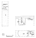
P8(fig. 90)(Matilda Webb and Madhavi Menon, 1993)
P8 consisted of two trenches, at right angles to one another, in order to investigate the presumed road intersection whose corner was occupied by an olive tree. In the northern trench a well preserved plaster floor (3) was delimited by a very vague line of foundations, 5, which consisted mainly of cut bedrock. North of this line, along what must have been street 8, the bedrock was smoothed, and covered by a compact layer of beaten earth, 2. This surface might be interpreted as a resurfacing of the road, and the presence of a sherd of ARS form Hayes 8A dates it between the end of the1st c. A.D. and the middle of the 2nd. A sherd of 7th c. pottery was found in topsoil. In the southern trench a plaster-lined vat 1m. deep and 1.10m. in diameter lay beside a cut-bedrock foundation very similar to that in the northern trench. It is probable that the vat lay in the same room as the plaster floor, but the trenches were too small to be sure. Outside the wall the presumed road surface of street P was no better made than that of street 8, but there was no evidence of building. Again, the floor and the wall were covered by tumble (9) and a thick deposit of pis» de terre, which filled the vat, covering a broken Dressel 1C amphora, which dates the abandonment of the structure to the 1st c. B.C. |
Part 2: The Stratigraphy
> The Sample Trenches
> P8
© 2002 Adam Rabinowitz and Elizabeth Fentress
Design © 2002 Adam Rabinowitz and Nicholas Rabinowitz
All rights reserved.